The Isaac Regional Planning Scheme helps us manage growth, plan for a sustainable future and guide the way land is used and developed in the Isaac Region.
The Isaac Region Planning Scheme 2021 (Planning Scheme) was adopted by Council on 24 February 2021 and came into effect on 1 April 2021. The current version of the Planning Scheme is Version 1.1 which came into effect on 1 July 2024.
The Isaac Region Planning Scheme 2021 does not apply to the Priority Development Areas within the Moranbah Priority Development Area or the area contained within the Galilee Basin Development Scheme (see schemes in later pages).
Council’s Online Mapping allows users to view property and land information, planning zones and aerial photography.
Access maps here
Isaac Region Planning Scheme Version 1.1
Amendments Under Preparation
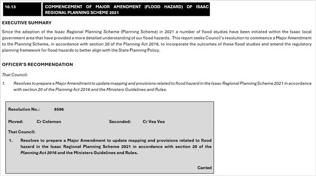
Major Amendment (Flood Hazard)
Council is proposing changes to the Planning Scheme to develop a more comprehensive approach to the regulation of development in flood prone areas. The amendment will also incorporate more detailed flood mapping developed as part of recent flood studies undertaken by Council.
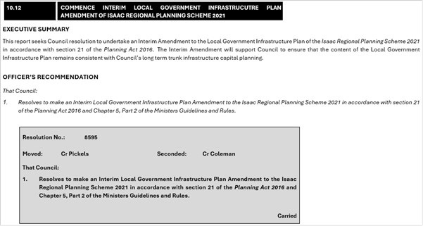
Interim Local Government Infrastructure Plan Amendment
Council is proposing changes to the Planning Scheme to ensure that the content of Council’s Local Government Infrastructure Plan remains consistent with Council’s long term trunk infrastructure capital planning.
Adopted Planning Scheme Amendments
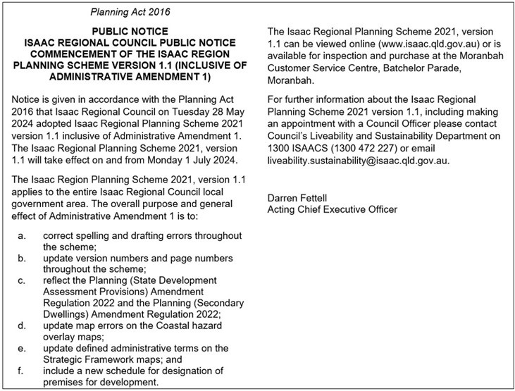
On Tuesday 28 May 2024, Council adopted Isaac Regional Planning Scheme 2021 version 1.1 inclusive of Administrative Amendment 1. The Isaac Regional Planning Scheme 2021, version 1.1 will take effect on and from Monday 1 July 2024.
The overall purpose and general effect of Administrative Amendment 1 is to:
- correct spelling and drafting errors throughout the scheme;
- update version numbers and page numbers throughout the scheme;
- reflect the Planning (State Development Assessment Provisions) Amendment Regulation 2022 and the Planning (Secondary Dwellings) Amendment Regulation 2022;
- update map errors on the Coastal hazard overlay maps;
- update defined administrative terms on the Strategic Framework maps; and
- include a new schedule for designation of premises for development.
A full list of the amendments can be viewed here(PDF, 297KB).
Version 1.1. of the Planning Scheme can be viewed here(PDF, 6MB).
A Planning Scheme is a living and evolving document that provides a set of rules and guidelines that regulate how land in specific areas can be used and developed.
A Planning Scheme is designed to shape future land use development decisions and address other matters related to land use and development.
The Isaac Regional Planning Scheme was developed with significant community input to ensure the delivery of development outcomes that are consistent with the communities needs and goals and support Council’s vision of being “a region that feeds, powers and builds communities, now and for the future”.
A planning scheme is the document a local government uses to tell the public and other levels of government how it plans to manage development and growth in its region and respond to long-term change.
Planning schemes are both:
- a policy document, setting out the long-term strategic vision for the local government area – typically about 20 years; and
- a legal document which sets out rules for regulating development and criteria for assessing development applications.
Planning schemes also include:
- the localised expression of state and regional planning policies; and
- planning for major local government infrastructure networks.
Planning schemes are written, adopted and applied under the Queensland Government’s Planning Act 2016. The Act provides the framework for Queensland’s planning system which is performance-based, applicant driven and established through a hierarchy of planning instruments. These factors influence, and in some respects prescribe, the content and layout of planning schemes.
For more general information about Queensland’s planning framework, refer to the Queensland Government’s Planning State Development website.
As a Council, we have a lawful obligation under the Planning Act 2016, to have a planning scheme and to review it every 10 years.
The planning scheme allows the community and Council to make informed decisions about what development can occur where and how the impacts of development will be appropriately managed.
It provides a framework for:
- making consistent, transparent and accountable decisions; and
- making decisions which contribute to, and do not detract from, achieving a shared longer-term
- vision for our region.
From an economic development perspective, the planning scheme can offer policy indications to the property and development markets, as to the form and nature of development that would be positively received in the region to support and stimulate growth in various contexts.
A Temporary Local Planning Instrument (TLPI) is a statutory instrument created under the Planning Act 2016. A TLPI may suspend or affect the operation of another planning instrument (e.g. the Isaac Regional Planning Scheme),but does not amend or repeal that instrument.
A TLPI can be effective for up to two years after its effective date, or sooner if stated in the instrument or repealed.
Generally a TLPI is created if:
- a significant risk of adverse cultural, economic, environmental or social conditions is happening in the local government area
- the delay involved in making or amending another local planning instrument (e.g. the planning scheme) would increase the risk
- a state interest would not be adversely effected by the proposed TLPI.
There are no TLPI’s currently in effect in the Isaac region.